![]()
An Overview of the Lewis and Clark Expedition
-by Al Bredenberg
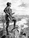
| These days, you can fly across the United States in six hours. Even if you have to take a car, you can do it in six days. But imagine what it would have been like two hundred years ago, when Meriwether Lewis, William Clark, and the other members of the Corps of Discovery traveled 3,700 miles from the Mississippi River to the Pacific Ocean in non-motorized boats, on horseback, and on foot. Not only did they have no cars or airplanes to travel in, they also had to do it with no reliable map -- and they had to make their way through territory inhabited by Indian nations who couldn't necessarily be expected to smile upon a band of armed explorers. |
 |
Planning the Expedition
| In 1803, when was President of the United States, the U.S. purchased the Louisiana Territory from France. This was a huge tract of over 800,000 square miles, taking in nearly the entire mid-section of North America from present-day Texas and Louisiana up to Montana and North Dakota. This almost doubled the size of the new country. Much of the new territory was unexplored. Jefferson decided to send an expedition up the Missouri River to its source in the western mountains and beyond to the Pacific Ocean. Jefferson hoped that the expedition would be able to find the elusive Northwest Passage, a water route across the country, which would be a great boon to commerce. So in that same year, Jefferson commissioned the Corps of Discovery under the command of his trusted private secretary, Meriwether Lewis. Besides seeking the Northwest Passage, Lewis was to map the new territory, assess its natural resources, and make contact with its inhabitants, befriending them if possible. Lewis recruited his friend William Clark to share equally in the command of the expedition, as well as a force of over 40 men. The members of the Corps of Discovery were soldiers, but their purpose was peaceful -- exploration, diplomacy, and science. Lewis was commissioned as a Captain of the Army of the United States, Clark as a Lieutenant (although this inferior rank was kept secret from the men, and Clark was always called "Captain"). |
| Lewis purchased a large stock of supplies, including guns and ammunition, food, clothing, navigational instruments, and large numbers of goods to be used as gifts and barter for Indians. To carry the Corps and its cargo on the first leg of their journey, Lewis had a keelboat built, a 55-foot shallow-draft vessel capable of carrying about 12 tons of cargo. The boat had a sail, but was mostly propelled with oars and poles. The journey on the Missouri River would be over 2,000 miles -- upstream all the way. | 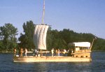 |
Up the Missouri
| The expedition started from St. Louis, where the Missouri empties into the Mississippi, on May 14, 1804. Along the way, Clark oversaw the men and carefully mapped the route. Lewis made scientific observations and collected specimens of animals and plants. The trip was arduous -- the men lived outdoors, hunted for food, and rowed the keelboat (along with two smaller boats) up the river, often towing the boat from the shore when the current got too heavy or the river became difficult to navigate. They fended off huge clouds of mosquitoes that swarmed around them. The party made only 12 or 14 miles on a good day. |  |
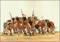 |
Along the way, the group made contact with Indian inhabitants of the land. During the first season of travel, they contacted the Missouris, the Omahas, the Yankton Sioux, the Teton Sioux (Lakota), and the Arikaras. The captains would offer gifts, meet with the chiefs, and make speeches encouraging the Indian nations to make peace with one another and with their new "great father," President Jefferson. All were friendly except the Lakota, with whom the expedition had a confrontation that nearly became violent. |
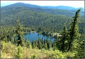
| By October, the Corps of Discovery had reached what is now North Dakota, but they were obviously nowhere near the Missouri's headwaters and winter was at hand. Since little was known about the route beyond the Mandan villages, Lewis and Clark decided to build a fort and winter with the Mandans and their Hidatsa neighbors. These tribes, with a population of about 4,500 people, occupied five permanent villages along the Missouri River and were known for their friendliness and generosity. |
Sacagawea
| During the winter, Lewis and Clark hired Toussaint Charbonneau, a French fur trader, and his wife, a Shoshone woman named Sacagawea, realizing that this woman could help them by acting as interpreter with her people, who lived near the Missouri's headwaters. | 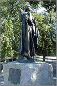 |
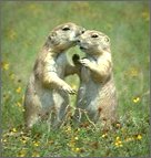 |
In the spring, the captains sent the keelboat back down the river with a few men and many items for Jefferson, including an interim report of the expedition, samples of soil, minerals, and plants, Indian items, and even some live birds and a prairie dog, which had never been heard of in the East. Most of the expedition continued up the river in canoes, taking along Sacagawea, her husband, and their newborn baby, Jean-Baptiste. |
| The group spent the next months making their way west up the river into territory unknown to white men. They encountered a great profusion of wildlife, including buffalo, wolves, bighorn sheep, and ferocious grizzly bears. They made their way into present-day Montana, and found the river becoming increasingly impassable, with fierce rapids and waterfalls. When they finally reached the area of the Missouri's headwaters, they sought out the Shoshones. As it turned out, Sacagawea's brother was chief of the village they first contacted. With her help, the party obtained the horses they would need to get across the mountains ahead. |
 |
Across to the Western Ocean
 |
As the party began crossing the mountains on horseback, it soon became obvious that the hope of finding a northwest water route was a false one. Jefferson had believed that the explorers, after leaving the Missouri, would find only a small mountain range with a river to the Pacific just a short distance on the other side. |
| In fact, the expedition had to make its way on the Lolo Trail across the vast Bitterroot Mountains, already covered with snow in September. The crossing took 11 days, during which the men nearly starved. They were almost helpless when they reached the Nez Percé Indians on the other side. Fortunately for Lewis and Clark and their group, the Nez Percé welcomed and fed them, helped them make canoes, and agreed to take care of their horses until their return on the way back east. With the water finally running west, the explorers quickly traveled down the Clearwater, Snake, and Columbia Rivers, reaching the Pacific coastal area in early November, a year and a half after leaving St. Louis. They built Fort Clatsop, named after the neighboring Indian nation, on the south side of the mouth of the Columbia, near what is now Astoria, Oregon, and spent the winter in cold, wet, miserable weather, preparing for the trip back home. |
Return Journey
| On March 23, 1806, the Corps of Discovery started on the long journey back the way they had come. They had some conflicts with some of the Indians on the lower Columbia, whom they accused of charging high prices for food, trying to steal from the travelers, and interfering with their progress. But when they reached the friendly Nez Percés, they found their horses alive and cared-for, though scattered on open range. The group was back across the mountains by June and decided to split up into smaller parties for a while so as to explore some of the territory more thoroughly. Lewis took a more northerly route, and it was during this trip that the explorers had their first and only violent conflict with Indians. A group of Blackfeet apparently tried to captured horses and guns, and Lewis's party killed two of them. At about that same time, Clark, on a southerly route, discovered an unusual, large stone formation on the Yellowstone River. He named it "Pompy's Tower," after the nickname of Sacagawea's son, now in his second year (certainly one of the most remarkable childhoods in American history). There on that formation, Clark left an inscription, "Wm. Clark July 25th 1806," which can still be seen today. The separate parties rejoined in August back on the Missouri River, at the mouth of the Yellowstone. They continued on down the river, dropping off Charbonneau, Sacagawea, and little Jean-Baptiste at the Mandan villages. Traveling quickly, they reached St. Louis on September 23, 1806. The men of the expedition were welcomed as heroes. They had been gone so long that the nation feared they were dead. Remarkably, only one member of the group died. This was Sergeant Charles Floyd, who probably died of a ruptured appendix as the Corps of Discovery traveled up the Missouri River on its way to the Mandan villages. |
Lewis and Clark and the Mapping of the Continent
| The Corps of Discovery returned with a great deal of knowledge about the new United States territory west of the Mississippi -- the people, the land, the rivers, the mountains, the plants and animals. The expedition made important contributions to the mapping of the North American continent.
|
![]()
![]()
![]()
Copyright 2000 Smithsonian Institution and EdGate.com, Inc. All rights reserved.