![]()
Lewis and Clark and the New Knowledge of the
West
-by Al Bredenberg
| The Lewis and Clark expedition supplied a great amount of detail for the map of the northwestern U.S., which had been sparse up until that time. The maps developed during and after the expedition presented much new information, including a greatly expanded view of the Rocky Mountains and a more accurate positioning of some of the western rivers. Also, the expedition forever dashed American hopes of finding an easy water route across the continent. | 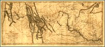 |
Clark's Map of 1810
| Along the track of their expedition, Meriwether Lewis and William Clark had kept detailed journals of their discoveries. Clark had made route maps charting the territory they passed through. Soon after returning from the journey, Clark began incorporating the new geographical knowledge into a large new map of the West. Appointed as Superintendent of Indian Affairs for the Louisiana Territory, Clark stayed in St. Louis and continued working on this map, completing it in 1810. Eventually much of this map was adapted and published in printed form by Samuel Lewis in 1814. In the wake of the Lewis and Clark expedition, other travelers penetrated the West and investigated other unknown regions. Many of these travelers -- including traders like Manuel Lisa, trappers like John Colter, and army explorers like Zebulon Pike -- later passed through St. Louis, where Clark was. Besides knowledge from his own explorations with Lewis, Clark incorporated information from these newer sources into the map he was creating.
|
Misconceptions Corrected
| Before the explorations of the Corps of Discovery, Thomas Jefferson and other geographers had filled in the empty space on the western map with hypothetical features based on rumors, legends, distorted versions of Indian information, and a certain amount of wishful thinking. |
 |
Much of this imaginary geography centered around the hope of finding a water route across the North American continent for commerce with the East Indies. In fact, the central purpose of the expedition of Lewis and Clark, in the words of Jefferson, was "to explore the Missouri river, and such principal streams of it, as, by its course and communication with the waters of the Pacific ocean, whether the Columbia, Oregan, Colorado, or any other river, may offer the most direct and practicable water-communication across the continent, for the purposes of commerce." |
| Prevailing thinking before the expedition went like this:
(Scholar John Logan Allen discusses this hypothetical geography thoroughly in his 1975 book "Lewis and Clark and the Image of the American Northwest," published now by Dover Publications.) |
| Rocky Mountains were a vast upland area, a complex system of massive mountains and deep valleys. The Missouri and other rivers were impossible to navigate at their higher reaches. The supposed one-day portage from river to river across an easy height-of-land turned out to be an arduous trek of over 100 miles, including the party's 11-day ordeal crossing the snow-covered Bitterroot Mountains, during which the group nearly starved (eating their horses saved them). |  |
A New Geography of the West
| Although Lewis and Clark -- and their mentor Thomas Jefferson -- were disappointed at not finding the fabled Passage to India, the expedition resulted in a much more accurate map of the American Northwest.
|
A New Generation of Western Maps
| Although the discoveries of Lewis and Clark destroyed some old misconceptions about western geography, they sparked the imagination of the new United States, primed for expansion. Its citizens could now see the very real potential of the West for commerce and settlement. The Lewis and Clark expedition was followed by increased exploration and trading, and eventually the annexation of the Oregon country to the far west. In the decades following Lewis's and Clark's journey, all this new activity resulted in further refinements and corrections to the map of the West. Very quickly, an accurate understanding of western geography developed, correcting the remaining errors on Clark's 1810 chart. To get an idea how quickly the mapping of the West progressed, take a look at the Anthony Finley map of 1826 and the David Burr map of 1839-40. Compared with older maps such as Arrowsmith's, Clark's represented the beginning of "an entirely new generation of American maps". |
 |
Lewis and Clark did not achieve the primary objective of their expedition, to find a water route across the continent. However, they did provide a much more accurate view of the American West. Their heroic journey marked a turning point in western exploration, in the history of the United States, its citizens and its native inhabitants, and in geographic knowledge of the North American continent. |
|
Copyright 2000 Smithsonian Institution and EdGate.com, Inc. All rights reserved. |