![]()
Route Mapping on the Lewis and Clark Expedition
-by
Ralph Ehrenberg
Preparation for the Journey
| Lewis and Clark and their Corps of Discovery have been referred to as "the writingest" group of explorers to undertake a major overland expedition. The same thing can be said for their mapmaking. They prepared about 140 maps on the trail and collected some 30 maps from Indians, fur trappers, and traders. Like writing, mapmaking requires special aptitude and training. But while nine of the 33 participants kept journals, only one drew maps. |
 |
Most of the maps were drawn or compiled by William Clark. Although Clark had little formal education, he displayed an inherent ability for mapmaking. He appears to have learned surveying and mapping on the Virginia frontier and in the Army. His first teacher was probably his older brother, the famous Indian fighter and Revolutionary War hero George Rogers Clark. His brother was also a land surveyor. As a young Army officer during the 1790s, Clark received further training in mapmaking. He was responsible for constructing military fortifications, a job that required skill in drawing and reading maps. |
| While Meriwether Lewis was not a cartographer, he carried out much of the celestial observation. He was tutored in this activity by some of America's leading scientists, mathematicians and surveyors. These included the third President of the United States and members of the American Philosophical Society. Using his own instruments, Thomas Jefferson personally taught Lewis the basic principles of determining latitude by observing altitudes of the sun or a star with an octant. |
 |
| Jefferson also sent Lewis away for further study. He learned about calculating astronomical formulas from Robert Patterson, professor of mathematics at the University of Pennsylvania. From Andrew Ellicott he learned field surveying. Ellicott was the foremost surveyor of his day. He had conducted numerous frontier boundary surveys, including the boundary between the United States and the Spanish possessions in Florida. In 1791 Ellicott prepared the first printed map of the nation's capital. No other American had more experience in making celestial observations in the field under trying circumstances. Ellicott prepared a list of the instruments that would be required to properly survey and map the explorers' route, and he instructed Lewis in their use. The two explorers used their first winter together at Camp Dubois (Wood) and in St. Louis improving their surveying skills and collecting geographical information about the route they planned to follow. From Dec. 12, 1803, to May 14, 1804, Clark, who was in charge of Camp Dubois, practiced celestial observation and mapmaking. At the same time, Lewis conferred with Spanish and French surveyors in St. Louis, gathering information and copying their maps. During the expedition, Clark prepared four types of trail maps. These were large-scale compass traverse maps, small page-size maps sketched in his journals, copies of maps prepared by traders and Indians, and composite maps of the West. |
| The primary maps prepared by Lewis and Clark were called compass traverse maps. These show the route that they traveled each day. The first step in preparing these maps required the determination of geographical latitude and longitude by celestial observation. This was done at selected places such as where major rivers joined the Missouri or Columbia rivers. A variety of instruments were used for this purpose. Longitude was normally determined with a chronometer (clock). To maintain accurate time, the chronometer had to be wound each day at noon. Sometimes the explorers forgot or did not have time to wind it. To reset the chronometer, the explorers had to take additional celestial observations. Lewis also tried to determine longitude by celestial observation, but without much success. This was a tedious job that required as many as three assistants and took most of an evening. |
 |
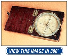
| The explorers were more successful determining latitude, which involves measuring the angle of the moon and a star with an instrument called an octant. Latitude was usually determined for each camp site. Other instruments that the explorers used in celestial observation were the sextant and artificial horizon. For pictures of and information on navigation instruments, visit: |
| Next, Lewis and Clark recorded the direction and distance covered for each leg of their journey. Direction was determined with a "circumferentor" or plain surveyors compass. Distances from point to point were generally estimated in miles. Clark and many of the soldiers were experienced woodsmen who were trained from childhood to estimate distances. |
 |
| In some instances, however, the Captains wanted more accurate measurements. For this they used a surveyor's chain made of iron links, each measuring 7.92 inches in length. The entire chain measured two poles (33 feet) and was called a "two pole Chain." The "pole" was a common unit of measurement during the early nineteenth century. One pole equaled 16 1/2 feet. The explorers also carried a "log line reel" for measuring speed and distance traveled on water. Although no description survives, log lines generally consisted of a rope line divided into known lengths. This line would be attached to a buoy or other stationary object in the water near the boat. As the boat moved forward, the explorers could then time the interval required for the line to be played out. The log line would also be used to determine the rate of the current. Why was this important? The distance and direction for each segment of the trip were recorded daily in their journals and field maps in the form of a table which Clark labeled "course and distance." A portion of a course and distance table is shown below. It covers a segment of their route for June 15, 1805. On this day they traveled twelve miles.
The first column expresses the compass bearing (course or direction) for the distance indicated. Bearings are expressed in degrees from due north or south. Look at the second line that begins with "S 28º W" or South 28 degrees West. This means that the expedition traveled along a route 28 degrees west of due south for two and one-fourth miles to a point in the river marked by a large rock in the shape of a tower. This rock was located on the right side of the river.
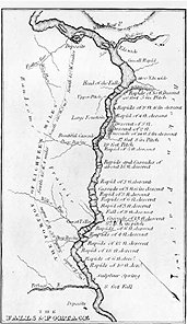
From these tables Clark plotted their route on maps called field sheets. The field sheets contained a background grid of one-inch squares to aid in plotting.
| |||||||||||||||||||
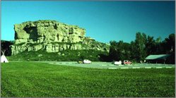 |
One of these finished maps shows Clark's return route along the Yellowstone River. It covers the portion of the route from "Pompy's Tower" to the mouth of the Big Horn River in present-day Montana. Today "Pompy's Tower" is called Pompey's Pillar. It is a large rock that was named by Clark in honor of the child of their Shoshone guide Sacagawea. |
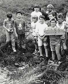
| You can still see Clark's signature on this rock, which he carved into the soft sandstone on July 25, 1806. In recognition of its historic association with Lewis and Clark, Pompey's Pillar has been designated a national historical landmark. For pictures and further information see: Giving names to unnamed features or places is one of the most important and creative acts of the mapmaker. Today this activity is coordinated by the U. S. Board on Geographic Names, located in Washington, D. C. The Board reviews all new names and name changes proposed by organizations or individuals. Information about the Board can be found here. In 1988, the second grade class of Sioux Valley Elementary School in Peterson, Iowa, proposed the name of "BlueBird Creek" for an unnamed stream near their school. This name was approved by the Board and now appears on all maps of that region. |
 |
| The Captains also drew small-scale page-size maps. These were drawn in their daily journals. Some are very detailed and show features that affected river travel, such as falls, narrows, and rapids. Others are merely sketches of large areas. A number were derived from Indian information.
|
| Lewis and Clark also copied or drew maps based on information that they received from traders and Indians. During the first half of their trip from St. Louis to the Great Falls of the Missouri, the two explorers were guided by traders and their French boatman who had visited this region. The further west that they traveled the more they relied upon Indian maps for geographical information that lay beyond their line of sight. These maps were generally sketched on the ground or on animal skin and then copied in their journals or on map paper. One of the few surviving maps drawn by Lewis is a detailed sketch of the Great Bend of the Missouri River in the vicinity of the junction of the Missouri and Knife rivers in present western North Dakota. It was copied from an original drawn by David Thompson, an astronomer and surveyor employed by a fur trapping firm named the North West Company. Thompson visited this area in 1798. His map also shows the number of warriors, houses, and tents of the Mandan and the Pawnee Indian villages. A notation added by Thomas Jefferson provides information on the latitude and longitude. You can see this map here. Another map associated with the Mandan Indians is a map of the Yellowstone River. It was based on information provided to Clark by a Mandan chief named Shahaka or Big White following his hunting trip to the Yellowstone River region of Wyoming in the winter of 1805. It is the first map to show this river and its tributaries. Most of the Indian maps collected by Lewis and Clark show areas west of the Rocky Mountains. Clark noted in his journal on Oct. 18, 1805: "The Great Chief and one of the Chim-nâ pum nation drew me a Sketch of the Columbia [River] above and the tribes of his nation, living on the bank, and its waters, and the Tâpe têtt river which falls in 18 miles above on the westerly side." |
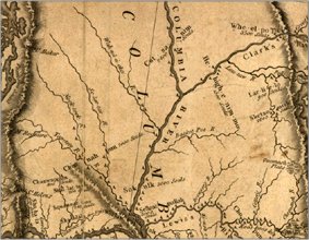 |
This map was originally drawn with a piece of coal on an Indian robe. It depicts the Upper Columbia and Yakima rivers in present-day southeastern Washington State, a region not explored by Lewis and Clark. This image is incorporated in Lewis and Clark's printed map of 1814. |
| The final type of maps compiled on the trail were composite maps of the West. Two were prepared. These were compiled by Clark during the long winter camps at Fort Mandan (Oct. 1804-April 7,1805) and Fort Clatsop (Dec. 7, 1805-March 23,1806). Both cover the entire West from the Mississippi River to the Pacific Coast. The Fort Mandan map is the first map of the West derived from personal observations and measurements. It was based partly on the explorations of Lewis and Clark and partly on Indian information. The depiction of the lower Missouri River was taken from Clark's finished traverse surveys and is quite accurately portrayed. The vast region to the west of Fort Mandan and the Missouri River was derived from Indian maps and verbal descriptions. The rivers shown are quite distorted because of the Indians' different concepts of space, time, and direction. Nevertheless, this information was extremely valuable to the explorers. It provided Lewis and Clark with an improved mental map of the West that helped them in planning the final leg of their journey. In one important aspect, however, this map was both comforting and misleading. Based on information received from a Gros Ventres Indian, Clark showed a dotted line extending from the Mandan-Hidatsa villages to the Columbia River. This line was labeled "The war path of the Big Bellies Nation." It showed that there was an existing Indian trail over the Rocky mountains that might be followed by Lewis and Clark. |
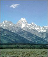 |
At the same time, the map showed that this trail passed over a single mountain range that suggested an easy crossing. The reality was quite different. The Lolo trail that the explorers followed over the Bitterroot mountains in modern day Idaho proved to be the most difficult part of the entire expedition. Instead of finding a low-lying single mountain ridge, they discovered numerous ranges of great height that extended nearly one hundred miles.
|
|
|